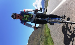
June 21, 2015
Kamloops to Cache Creek
Happy Father’s Day and Happy Solstice to all the druids out
there.
I was really surprised when I crawled out of my tent this
morning. The forecast had called for
sunny skies with a high of 30 C (80F), so instead of the bright sun and balmy
weather it was cold, 5 C (40F) damp and heavily overcast with the clouds
hovering close to the hill tops. So I hurriedly
pulled on some arm warmers, heavy gloves and a rain jacket.
We had filled our selves with cereal, yogurt and peanut
butter before heading off. Kamloops was
20 kms down the road. In Kamloops you
have to take the downtown ramp as bicycles are not allowed on the city
bypass. The only problem with this is
that there is an enourmous hill which has to be climbed to get out of town on
the other side. We had a planned stop at
a Tim Hortons which was about 80% of the way to the top. It was a welcome stop. After coffee all of the coats and heavy
clothing was dropped in the van as the sun was now out.
The next stop was at the 60 km (37.5 mi) mark at the top of
the outlook over Kamloops lake. It is a
magnificent view down the lake and you can see all the way to Kamloops. After some energy bars and some water we were
off again. There some good down hills
and a lot of big grind up hills. The
shoulder was nice and wide however it was kind of rough so you had to decide to
ride in traffic on the smooth pavement or on the shoulder. The last 15 kms had a stiff head wind so
everyone was tired when we got in.
It was a very fun day and while only 100 kms (62 miles) it
was a full day.
Terry


2 comments:
The Kamloops area is similar to Arizona in some ways, very picturesque but more elevation changes. Nice pics. I see that you will have close to 12,000 vertical feet on the 134 miles between Cache Creek and Whistler. Eat your wheaties!!
I have good memories of Kamloops. Enjoy your pictures. I have to think back to what it is like riding in the wet and cold. Keep up the good work..
Post a Comment