Thursday, June 12, 2025

Rockies IV June 12 Cranbrook to Kimberly


Rockies IV

June 12, 2025

Cranbrook to Kimberly

It was raining this morning when I woke up.  It sounded really heavy but when I crawled out of the tent I was shocked at how little rain there was.  In fact there wasn’t even enough to make the pavement wet.  
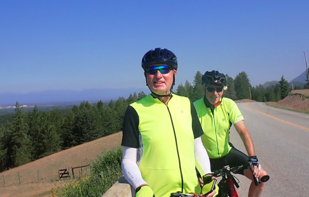
Today’s ride was up the bike path to Kimberly.  This is one of the premier rides of this tour as it is a wonderful paved path which connects Kimberly to Cranbrook.  As an old rail line it is a low grade climb all the way up to Kimberly and a fantastic sail back to Cranbrook.

We were out of camp and on the road about 9:00 am.  It was totally gray and overcast from the early morning rain.  Even though I had only put on a jersey I was warm enough as we climbing all the way.

After a couple of pictures, I was disappointed to find my camera was out of battery.  I had checked it and it looked like there was a ¾ charge.  It may be time for new batteries as the other battery I have for the camera had swelled and I had a very tough time getting it out of the camera. 

The over cast sky didn’t last long and by time we were half way to Kimberly the clouds were breaking up and there were patches of blue sky. By time we got to Kimberly it was pretty nice.   In Kimberly they are replacing the water mains and as a result A&W was closed. 

After a quick stop at the local market we were on the way home.  Flying down the hill was fast and fun. I stopped and took a couple phone photos.

Back Cranbrook I wheeled in to A&W with the two Kens while Barry headed off to the bank. It was very good, but not quite to the Quail Ridge A&W standards.

We rolled back to camp just as the rain started. Lots of thunder but the power is still on.

A great ride today  of 62 kms.


Terry   


Wednesday, June 11, 2025

Rockies IV Wardner Loop June 11 2025


Rockies IV

June 11, 2025

Wardner Road Loop

This morning, I set off with the two Kens about 8:00 am.  We were headed for what we have named the Wardner Road Loop.  It is a total distance of 88.3 kms and from the campground we head to Fort Steele the historic village, from there we ride down the Wardner Road to Hwy 3.  On to the hwy for a few kilometers before turning off towards Wardner.  Wardner shows up on Google maps but that is about all as there is no real village or anything.  From there we turn off the road to the HaHa Creek road which winds through the back country before rejoining Hwy 3 back to Cranbrook.  This one of the premier routes here in Cranbrook. The road from Fort Steele down to Hwy 3 is 21 km of the smoothest pavement anywhere with absolutely zero cars.  As there is nothing at Wardner  there are no cars and with a name like Haha Creek you just know that a back road like that is totally abandon.  The last 20 km into Cranbrook down Hwy 3 is pretty busy but with a very nice 6 ft wide shoulder protected by a rumble strip is a good ride.

Sailing along the Wardner Road, I think I must of said “this is just great “ at least a dozen times as Ken C finally said yes you have mentioned this a couple of times. It was just one of those magical moments when everything was perfect. 

We did not see any eagles fishing along the river this year as we have always seen them every time we have ridden this route. However, after we turned onto the HaHa Creek Road we did see the eagles circling the fields looking for lunch.  There in the big nest on one of the poles was a chick screaming for lunch.   

At the 65 kms mark we rejoined Hwy 3 back to Cranbrook.  It was around 28 C so it was getting pretty hot and humid.  Ken C and I waited quite a while for Ken T has he had some leg cramps. 

The last 23 kms into Cranbrook has a large hill of about 12 kms at up to 9% so it is always a huge grind.  However it went by quickly enough and Ken C and I headed into Save On where we indulged in a 2 liter jug of chocolate milk.  Ken T doesn’t drink  chocolate  milk.

In summary I am going to give this ride a 15 out of 10.  It was just great.   How do you top this.

Terry

Quick note Barry did not join us as he was having warrantee issues with his bike but has that all straighten out now.  


Tuesday, June 10, 2025

Rockies IV June 10 2025 Cranbrook


Rockies IV

June 10, 2025

Cranbrook

Yesterday Barry and I packed up in Kelowna for the drive down to Cranbrook.  We were aiming to be out of town by 8:30  and made it by 8:15 so we were doing well.  Traffic was light and we were making good time on the 6 hour drive.  About 90 minutes in we stopped for a bio break.  I checked the bikes on the rack and everything looked good.  However things were not so good as about 10 minutes later I looked back and saw Barry’s bike come off the rack.   How this happed is beyond explanation as I have used this bike on countless other trips and there has never been any issues.  This accident broke the two rear A frames of the bike.  As this was a fiberglass frame the bike was totalled.  What a disaster! 

This morning Ken C and Ken T got their bikes and headed off to Kimberly.  This is the premier ride out of Cranbrook as it is a 31 km one-way paved bike trail. It was a beautiful day to be out on your bike. 

Barry and I were off to the local bike shops to find him a new ride.  The first shop we spotted a really nice looking red Specialized which was on sale for a steal of a price. All carbon with Ultegra gear.  The second shop was a used sporting goods store.  They had a huge selection of junker bikes but nothing anybody would seriously want to ride.   The third store had a really high-end Trek with Di-2 electronic shifting but it was just a little too big.  Barry was looking for a 54 and it was a 56 cm frame.  Barry finally settled on the Specialized and even talked them down $250.  The shop remounted the rear cassette from his old bike to give him a little extra climbing ability.  It is a real beauty.

Barry rode back to the campsite and got there just as the two Kens rolled in from their first day’s ride. 

Quite a start to the tour. 

Terry  


Wednesday, September 18, 2024

 Offa's Dyke 

Bodfari to Prestatyn

September 18 2024


This morning our taxi was waiting to pick us up from the hotel and ferry us back down to the Dyke Path where we had been picked up last night.  Judy was not going to walk with us this morning so she stayed with the taxi who transferred the luggage up to Prestatyn.  

Naturally the trail headed straight up and it was really steep.  I had thought it was going to be a sunny day but instead we had a dark gray cloud cover and 100% humidity.  Naturally we took a wrong turn half way up the first hill and wound up walking around the hill side looking for the trail.  Ken had his Garmin out and we were back on track. 

Lost notwithstanding we made pretty good time for the first big lump in the route and within a couple of hours we were 4 miles into the trail.  This put us at the top of the first big hill and we were facing a really steep down hill.  Fortunately the trail had a lot of turns, and the path had dried considerably so the down hill wasn't so bad.  

The second big hill was right in front of us and we powered up it over the next hour which put us at lunch time so we sat down to eat the snacks we have been accumulating in our pack. By now the sun has burned off the heavy gray clouds and we have a bright blue sky. 

After the second big hill we ran into what seemed like and endless bunch of stiles.  Some were easy and some were really high and hard to get you foot over.  There were places were you climbed over one crossed the road and climbed a second one.  Then there were the stone ones where there was about four stone steps and a really high stone you had to clear to get over the top.  All these stiles just killed our pace. 

By now we could see Prestatyn and we were hot to get in but there was what seemed like a lot of miles, hills and stiles to climb.  So by the time we got down to the Nova center (kind of a community rec center) which is right on the ocean and the end of the Offa's Dyke trail, we were tired but happy.  Putting the last stamp on my Offa's Dyke passport was great. 

Off to the airport and home in the morning.  

Another great adventure in the books. 

Terry 


Tuesday, September 17, 2024

Offa's Dyke

Clwyd Gate to Bodfari

September 17, 2024


After a great breakfast in the Druid Inn we were driven back to our pick up point from the previous evening.  While in the car I asked what the history of the Druid Inn was as it was filled which interesting photos and really old looking antiques.  Turns out the Inn was built in 1747 and has been added to several times but has been in continuous service as an inn from when it opened in 1747 (Wow 277 years).

The trail started up almost straight up and continued straight up for almost 6 miles to the Jubilee Tower.  It was built in 1810 to celebrate the Golden Jubilee of George III.  It has been semi restored but is missing its top section.  It is the highest point on the Clwydian range of mountains.  As we climbed the hill you could see it for at least five miles off.  The view from the top of the tower is unbelievable.  We had the perfect day for it as well with a temperature of 65F and with a very light breeze out of the SW.  

Even though it was the highest point didn't mean that everything was down hill from there. We had a lot of really steep downhills followed by a lot of really steep up hills.  The mountains here are really tricky as well as everyone of them has at least 5 or 6 false summits.  So just as you think this one is done you come over a crest to see yet another steep stretch in front of you. 

At about the 7.5 mile mark we came to the Byngaer Moel Arthur Hill fort. It is a bronze age fort and can be seen for miles.  The dirt earth work crowns the hill.  The trail originally went up to the fort but has been diverted around the hill fort due to erosion of the trail. 

At the 9 mile mark Ken had a vertigo attack and found he was having trouble balancing.  As long as he kept his head up he was fine but we had a lot of hills to decent and a lot of them were really steep (30%).  How he made it is a mystery to me.  After a couple of miles his vertigo dissipated, but it was pretty scary. 

We managed to stumble down to the pick up point at 12.26 miles with 2690 feet of elevation gain.  The taxi picked us up and whisked us off to a very nice hotel.  

A great day but every one is really beat.  

Terry 


Monday, September 16, 2024

 Offa's Dyke 

Llangollen to Clwyd Gate

September 16, 2024


Last night Judy found a sporting goods store in Llangollen which opened at 9:00 am this morning.  As a bit of background to this Judy's hiking boots blew out on her on day one of this trip and she has been walking in tennis shoes this whole time.  I cannot believe what a trouper she is. Her feet were wet and cold but never complained for one second.  So Judy was off at 9:00 am sharp to get new hiking boots. This enabled us to have second and third coffees at the Squirrel B&B.  Dave from the Squirrel was driving our luggage ahead to Clwyd's Gate and he said jump in and we rode with him up to Llandegla.  This put us 8.3 miles up the road and passed the biggest hill.  It also gave us an easy day of only 6.2 miles to the pick up spot.  

It was by far the nicest weather of the trip today with just a hint of a breeze and temperatures close to 70 F.  The views along the path were spectacular.  Judy was dancing around in her new shoes and there was a real joyous mood.  Such a contrast from the other day slogging down muddy paths in the pouring rain and howling wind.  

We stopped at a bench which over looked the valley below and ate some snacks for our lunch.  Nobody was hungry as we had had such a huge breakfast at the Squirrel not that long ago.  The view and the sun were just so great.  

It wasn't long before we got to the pickup spot and I phoned the Druid Inn to come pick us up.  Sam answered on the first ring and promised to be there in 10 minutes.  She whipped us up to the Druid and we sat in the patio out front enjoying a pint and the sun.

The Druid Inn is a quaint little inn out in the country so we will eat here tonight.  A lot of people poo poo English food, but I have to say that we have eaten like kings on this trip.  The food has been spectacular everywhere we have been.  Maybe its Welsh food which has been so good.  

A shorter day but a great day and the weather for the next couple look good.  

Terry 


Sunday, September 15, 2024

 Offa's Dyke

Oswestry to Llangollen

September 15 2024


When we got on the road this morning the rain was coming down pretty steady, and the wind was whipping the trees around.  Fortunately most of the time we were in quite heavily wooded country so it wasn't too bad.  As we left the town of Oswestry the sign said  Trefonen so who knows.

As we climbed steadily we entered Race Course Woods which last nights host said was very beautiful and it was.  Unfortunately we took a wrong turn some where in the maze of trails in the large walking park and wound up putting on about and extra half mile of tramping in the rain.  When we go to the top of Race Course Woods hill we came to the ruins of the old stadium for the race course.  It was built in the early 1800's but was only open for a few years until the lower class's horses started winning and then it was shut down (that is what the sign said).  

It was a fairly steep down hill from the race course. Even the road was 17% so you can imagine how steep the trail was.  The steep wet grass and muddy trail made the going slow,  So between the rain, wind, and steep trail no bodies spirits were very high.  So I made a remark about how nice it was that the rain had turned to a heavy drizzle from the pouring rain.  This was meet with a bunch of growls and remarks that I should be called Mr Happy. 

We got down about the 9 mile mark and found that there was a diversion where some work was being done on the trail and we had to make the detour.  We could see that it was only about 50 feet of work and I am sure we could have walked past it however it was barricaded so we has to take the 1.5 mile detour to mark what was no more than 100 meters.  

After a bunch of ups and down and following some really high dyke path where the dyke was a good 30 feet high we came down to a busy road.  Ken's knee was done and Judy was cold, wet and tired.  There was bus stop there but no bus on Sunday.  Ken wanted to go to Chirk which was about 2 miles in the wrong direction and hopefully find a taxi.  I looked on my Here We Go app and saw that it was about 1.5 miles to Pontfadog.  The Swan Inn showed up on the app so even if we could not get a taxi it would at least be in the right direction.  So off the trail and down the busy road with no shoulders.  

We trouped into the Swan in a pretty bedraggled bunch.  The lady behind the bar said she would look for a taxi for us but didn't hold too much hope.  So while she looked for a taxi we sat and drank our beers.  About 20 minutes later she cam out and said no taxis but if we didn't mind squeezing into her little car she would drive us over the hill to the Squirrel B&B where we are staying.  It was only 3.3 miles and a really steep and bumpy back road.   We were delighted. She was off work in a few minutes and we piled into her little car and we were off.  She saved us. 

Over all we wound up with about 13 miles and 1755 feet of elevation.

Terry